


Forecaster: Nick Dunn (7/14/2019)
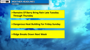
OHIO – Good Sunday Evening, everyone! Hopefully everyone had a great weekend. We have a couple of weather headlines we are monitoring for the upcoming week. The remains of Barry and a Heat Wave are the two major headlines.
We will have some dry time to start the week for most, with only isolated shower or thunderstorm chances for Monday and most of Tuesday. By Tuesday Night, steady rains move into the area and carry into Wednesday. When we look at the Precipitable Water Values (or how much water can be “rained out” of the atmosphere), we will be feeling very tropical for the entire day Wednesday. Some localized heavy rain is possible, with over 1″ of rain through Thursday expected.

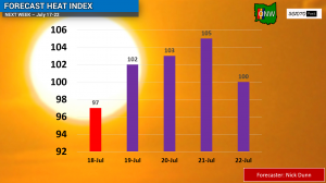
Once the remains of Barry depart for late Thursday through Sunday, oppressive heat will begin to build across the area. This heat wave will not be record breaking by any means, but it will be dangerous as some of us rival some temperatures we saw during the summer of 2012.

The heat index will rise to near or over 100 degrees for five straight days beginning Thursday. This will mean we could see Heat Advisories or Warnings issued. Also, heat of this magnitude can be stressful to your body if you are not taking care of it. It will be important to be drinking plenty of water and staying in the air conditioning as much as possible.
The good news is that as we look into the following week, we should see the heat and the ridge of high pressure begin to break down and we will see temperatures fall to more seasonable levels.
Stay tuned for updates all week here on Scioto Post!


