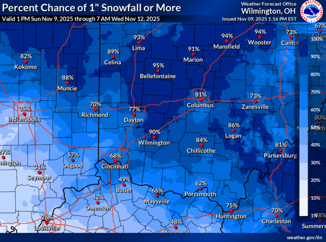
OHIO — Winter may be arriving a little early this year as the National Weather Service (NWS) is tracking a system that could bring light to moderate snowfall across much of Ohio and parts of northern Kentucky and Indiana in the coming days.
According to the NWS experimental probabilistic snowfall forecast, most of southern and central Ohio — including Columbus, Chillicothe, Logan, and Portsmouth — could see around 1 inch of accumulation, with higher totals possible in some areas. The data suggests that there’s a 90% chance these areas will see at least a dusting of snow, though heavier amounts are unlikely.
Communities in the northwestern part of the state, such as Bellefontaine, Marysville, and Sidney, have a greater potential for heavier snow. Forecast models show these areas could see up to 5 to 7 inches in higher-end scenarios, though expected totals are closer to 1 inch.

In contrast, parts of northern Kentucky and southeastern Indiana are expected to receive less than an inch, with only a small chance of exceeding 2 inches.
The NWS emphasized that this forecast is experimental, providing a range of possible snowfall outcomes to better communicate uncertainty. The agency continues to monitor the developing system and will release updated snowfall projections as the event approaches.
For now, Ohioans should prepare for potential slick roads and reduced visibility during early snow showers but not expect a major winter storm.
To see detailed snowfall maps and local probabilities, visit the NWS Probabilistic Snowfall Portal at weather.gov.


